By Matija Šerić
In October 2018, Iran’s Supreme Leader, Ayatollah Ali Khamenei, delivered a speech at Tehran’s Azadi Stadium before 80,000 members of the Islamic Revolutionary Guard Corps (IRGC) to promote the patriotic political program “Islam First.” He told his compatriots that they should be proud of Iran’s prestige in the region and the world, and of its invincibility. “The essence of my speech today,” Khamenei said, “first represents Iran’s greatness; second, the sovereignty of the Islamic Republic; third, the invincibility of the Iranian nation.”
Khamenei emphasized that Islam enabled Iran to preserve its territorial integrity and to independently confront “global arrogance” (the Iranian euphemism for Western imperialism, particularly American). “I point to the invincibility of the Iranian nation—which is, of course, due to Islam. This invincibility can be seen in the nation’s victory… against Saddam’s invasion and in resistance to hostile conspiracies over the past 40 years.”
Natural Features Unlike Anywhere Else
There is no doubt that Islam, or more precisely the theocratic Islamic system that has fully defined Iranian society for nearly half a century, has greatly contributed to the invincibility of the Islamic Republic of Iran. A return to the original faith revitalized the Iranian nation and made it proud and resilient in the face of regional and global challenges. However, Iran has also been—and remains—invincible thanks to its natural features. Although there have recently been indications that a (larger) war between Iran and Israel could break out, and that the United States might become involved, potentially even launching an invasion aimed at restoring the Shah, a detailed look at Iran’s geography shows such a scenario to be highly unlikely.
Unique Geography – A Historical, Not Just Geographical, Fact
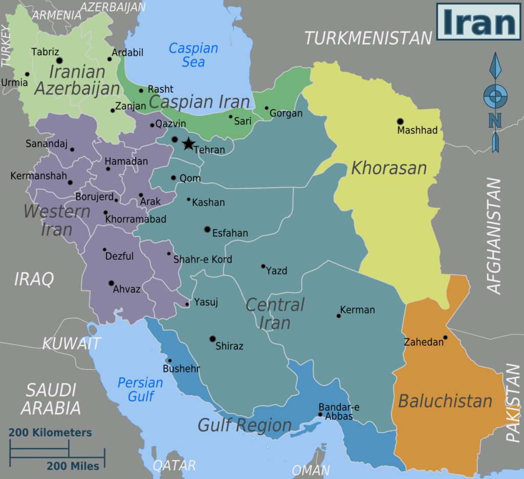
Iran lies at the heart of the Middle East and is, in many respects, a country that has fascinated visitors for millennia with its rich historical and cultural heritage and, above all, its unique geography. Iran is an exceptionally diverse country in geographical terms. It stretches from the Caucasus in the north to the Persian Gulf in the south, bordered by mountains to the north, west, and east, and exposed in the south to a hot desert landscape. Due to its geographical position, Iran is practically an impregnable fortress—a fact repeatedly proven by history.
Iran is a land of great climatic and topographical contrasts. From the dense, humid forests of Mazandaran province in the north to the arid coasts of the Persian and Omani Gulfs; from the high and cold mountain ranges of Alborz, Zagros, and the Caucasus to the deserts of the center and south. Beyond areas of fertile agricultural land expanded through creative irrigation from underground waters, vast regions of mountains and deserts or semi-deserts exist—unsuitable for crop cultivation but suitable for livestock grazing during certain parts of the year.
Mountains and Plateaus
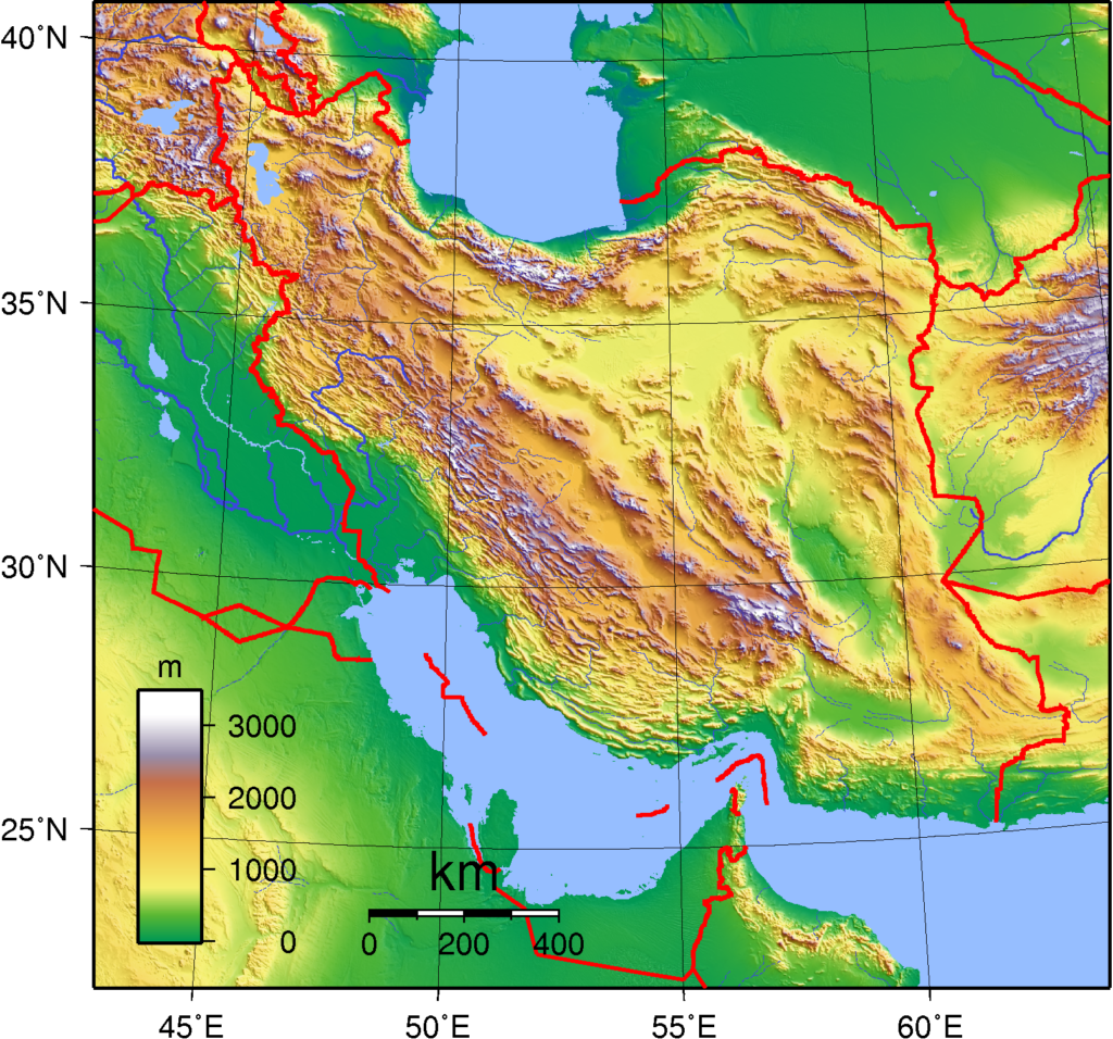
Mountains protect Iran on three sides (the Alborz, Zagros, and Eastern Iranian mountain ranges), while the sea protects it on the fourth (the Persian, or Arabian, Gulf). In the north lies the Alborz mountain range, stretching about 600 km from the Armenian border along the entire southern coast of the Caspian Sea to the border with Turkmenistan and Afghanistan. Alborz offers a spectacular natural landscape, including Iran’s highest peak and a stratovolcano, Mount Damavand, rising 5,610 meters. Beyond breathtaking scenery, Alborz is also the source of rivers that shape fertile valleys such as the Caspian region, where numerous crops are grown.
To the west, the Zagros mountain range extends along the Iran–Iraq and Iran–Turkey borders all the way to the Strait of Hormuz in the Persian Gulf, with a total length of about 1,600 km. The range includes numerous peaks over 3,000 or 4,000 meters. In addition to forming a natural border, it is rich in oil and gas; most Iranian oil fields are located in Zagros. The massif is also home to many ethnic groups that shape the country’s cultural diversity.
Deserts
Eastern Iran is shielded by the Eastern Iranian Massif, connected to plateaus covered by two salt deserts: Dasht-e Kavir (the Great Salt Desert) and Dasht-e Lut. Aside from scattered oases, these deserts are uninhabited. Central Iran consists of several plateaus collectively known as the Iranian (Persian) Plateau. The average elevation is around 900 meters, though several mountains rising above it exceed 3,000 meters. Iran has only two lowlands: the Khuzestan plain in the southwest and the Caspian coastal plain in the north.
Diverse Climate
A defining feature of Iran is its diverse climate. From subtropical conditions along the Caspian Sea coast to desert climates in the central regions, Iran offers varied conditions for life and agriculture. Northwestern regions near the Turkish border have a temperate climate with abundant rainfall, enabling lush vegetation and forests. In contrast, southern and eastern parts of the country are predominantly desert, with sparse rainfall and extremely high summer temperatures. These areas face challenges of drought and desertification but are also home to numerous nomadic communities adapted to harsh conditions.
The Impossibility of Conquering Iran from the East, North, or West
The Mongols were the last force to successfully invade Iran in the early 13th century; since then, all attackers have been stopped by the mountains. Considering a potential foreign invasion—likely only by the United States, given Iran’s geography—planning an invasion from eastern Iran via western Afghanistan would be logistically impossible. This is due not only to Taliban rule there but also to the shape of Iran’s eastern borders. First, the Eastern Iranian Massif runs along the border. Second, traveling from the Iran–Afghanistan border to most major Iranian cities would require crossing two vast deserts: Dasht-e Lut and Dasht-e Kavir.
Surface sand temperatures in Dasht-e Lut have reached as high as 70°C. Dasht-e Kavir consists of salt marshes (kavirs) covering dense mud; it is easy to break through the salt crust and sink into the mud. Such terrain would prevent the use of mechanized and armored forces. An attempted U.S. invasion from the north or west would be no easier. Although northwestern Iran borders Turkey, a NATO ally of the U.S., Ankara would almost certainly not allow its territory to be used as a staging ground for an invasion—just as it refused in the case of Iraq in 2003. Regardless, the Zagros range, defining the Iran–Turkey border and much of the Iran–Iraq border, would render any invasion completely unfeasible.
Shatt al-Arab
A potential, though unlikely, avenue of advance in western Iran lies at the far south, where the Tigris and Euphrates rivers merge to form the Shatt al-Arab, about 200 km long, flowing into the Persian Gulf. This was the invasion route used by Iraqi forces in the 1980s. In practice, however, Iraq discovered it to be marshland that is easy to defend. Even if invading troops crossed this area, they would soon encounter the Zagros mountains. Nevertheless, the Shatt al-Arab basin was long considered Iran’s Achilles’ heel, which is one reason Tehran invested heavily in gaining influence over Shiite Iraq. Given strong Iran–Iraq relations, the U.S. would find it difficult to use Iraq as a springboard for an attack.
The Possibility of an Amphibious Invasion from the South
The only plausible U.S. attack route would be from the south, via the Persian and Omani Gulfs. Iran’s coastline stretches 2,815 km. Iranian authorities have prepared for such a scenario for decades, focusing on denying U.S. naval access through the use of large numbers of precision-guided and conventional missiles, naval defense vessels, drones, submarines, and mines. Numerous coves, islands, and islets along the coast provide ideal concealment for small attack boats and camouflaged missile systems.
The narrow confines of the Persian and Omani Gulfs hinder effective maneuvering of large U.S. warships and aircraft carriers, which could become easy targets for Iranian missile and air–naval forces. If necessary, Iran could retaliate by closing the Strait of Hormuz, through which 25% of global oil trade and one-third of global liquefied natural gas (LNG) trade pass. At its narrowest point, the strait is only 34 km wide. Closure would send global oil and gas prices soaring.
Vast Territory and Enormous Population
Iran is vast in both territory and population. With an area of 1,648,195 square kilometers, it is larger than France, Germany, Belgium, the Netherlands, Portugal, and Spain combined. Invaders would fare poorly in Iran, as demonstrated by the example of Iraq. Iran today has roughly three times the population Iraq had in 2003 at the time of the U.S. invasion. Iran has six cities with over one million inhabitants. Tehran, with 9.6 million people, is the world’s 38th largest city—larger than global metropolises such as New York (7.9 million), Riyadh (7.8 million), Madrid (6.7 million), and Rome (4.3 million).
Overcrowded Urban Areas
The terrain is ill-suited for the movement of large invasion forces. Since almost all major Iranian cities are located in the north, reaching them would require superhuman efforts. With a population of 89 million, Iran is the world’s 17th most populous country—equivalent to the combined populations of Canada, Poland, and Sweden. Even if foreign invaders somehow penetrated deep into Iran, beyond geographical obstacles they would face the sheer number and density of hostile populations in large urban centers—an almost insurmountable challenge.
Iran’s terrain is more complex than Iraq’s, with more mountains, ranges, and steep slopes, making effective control of occupied territory even harder. Outside cities and suburbs, invaders would struggle regardless of whether they sought to hold the coast, mountainous regions, or plateau settlements. They would quickly face fierce guerrilla resistance, including suicide bombers and other high-risk attacks inspired by loyalty to Islam and the revolution. Much of Iran’s population lives outside cities in mountainous areas. The Islamic Revolutionary Guard Corps has long developed plans for a guerrilla campaign against invading forces attempting to move from the coast toward northern cities.
Strong Motivation to Defend the Revolution
American experiences in Vietnam, Somalia, Iraq, Afghanistan, and elsewhere are reminders that U.S. forces are rarely welcomed—even when their occupation ostensibly brings noble “gifts” such as freedom, human rights, and democracy. Iran lost around half a million people fighting Iraq in the 1980s in a war Iranians believe was inspired by the U.S. to destroy the Islamic Revolution. The Iran–Iraq War motivated citizens to support the Sharia-based Shiite regime. It is hard to believe that Iranians would simply allow occupation of their country—even considering dissidents empowered during protests following the tragic death of Mahsa Amini in autumn 2022 and the latest protests earlier this year.
Internal Uprising – The Only Card for Foreign Powers
Finally, Iran’s armed forces rank as the world’s 15th strongest military. At any given moment, they have 587,000 active personnel and 200,000 reservists who can be mobilized immediately in case of danger. Iran has a highly developed program of drones, ballistic and cruise missiles, tanks, and armored vehicles. Were it to develop nuclear weapons, it would unquestionably become the most powerful force in the Middle East.
All of this is well known to American, Israeli, Saudi, and other strategists who would like to see regime change in Tehran. Thus, they place their hopes in internal unrest and some new “Orange Revolution,” since the Islamic Republic cannot lose a conventional war.